Travel Guide, Ha Giang Loop
Top Must-See Ha Giang Loop Highlights For Backpackers
Dec
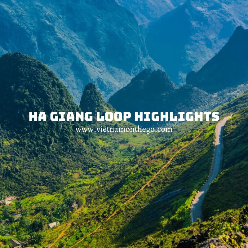
Embarking on the Ha Giang Loop in Vietnam is an adventure of a lifetime, offering an immersive experience in one of Southeast Asia’s most stunning and culturally rich landscapes. This remarkable loop, stretching over 350 kilometers in the northernmost region of Vietnam, is not just a journey through breathtaking sceneries; it’s an exploration of cultural diversity, historical richness, and geological wonders. From winding mountain passes to lush valleys, and ethnic villages to bustling markets, the Ha Giang Loop highlights encapsulate the spirit of Vietnam’s highland frontier.
About the Ha Giang Loop
The Ha Giang Loop is a breathtaking journey through one of Vietnam’s most spectacular regions, Ha Giang province. This epic loop, often traversed by motorbike, spans approximately 350 kilometers, winding through rugged mountains, verdant valleys, and traditional villages. The journey typically starts and ends in Ha Giang city, taking travelers through a mesmerizing landscape that includes the towering Ma Pi Leng Pass, the serene Nho Que River, and the unique Dong Van Karst Plateau Geopark.
As riders navigate this challenging and exhilarating route, they encounter diverse ethnic communities like the H’Mong, Tay, and Dao, each with their unique cultures and traditions. The Ha Giang Loop is not just a journey through physical landscapes but also a cultural exploration, offering insights into the lifestyles of Vietnam’s northern highlands.
The best time to embark on the Ha Giang Loop is from March to May and from September to November when the weather is most favorable. Each season brings its own charm, from the blooming buckwheat flowers in autumn to the lush greenery in spring. This journey is a must-do for adventure seekers and those looking to experience the raw beauty and rich culture of Vietnam’s frontier regions.
Highlights During the Ha Giang Loop
Ma Pi Leng Pass
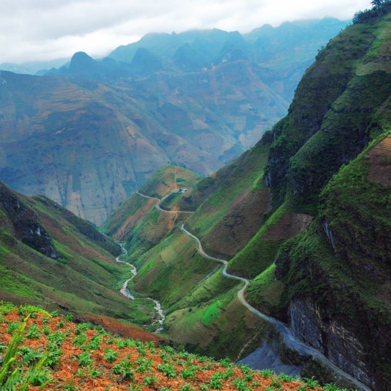
The Ma Pi Leng Pass, located on National Highway 4C within the territories of Pai Vi and Pai Lung communes, connects the city of Ha Giang with the towns of Meo Vac and Dong Van. Known as one of the “four great peaks” of Vietnam, this pass is a renowned tourist destination in Ha Giang.
Spanning 20 kilometers, Ma Pi Leng is a winding and treacherous mountain road, situated over 1,200 meters above sea level. Adventurous travelers can explore this challenging route, navigating tight curves between steep cliffs and deep gorges. Along the way, don’t miss stopping at the ‘Death Cliff’ on the mountainside for breathtaking photo opportunities.
Reaching the summit, visitors are rewarded with panoramic views of the vast Dong Van Stone Plateau and the serene Nho Que River flowing at the mountain’s base. Here, you can engage in activities and even camp overnight. Moreover, visiting during the rice harvest season or the blooming season of buckwheat flowers offers a chance to witness the stunning beauty of terraced fields and floral valleys.
Tu San Canyon
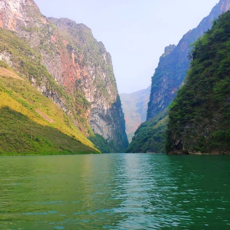
It is the deepest canyon in Southeast Asia, situated between the mountains of Meo Vac and Dong Van. You will come across villages you haven’t seen in a while as you gently wind your way down to the base of Meo Vac Mountain. There are terraces all around them, and down below is Tu San Alley, where you can take a boat ride on the Nho Que River and rest your hips.
Having a boat experience during your Ha Giang Loop trip sounds amazing. See the ethnic kids playing by the river or the fisherman relaxing on his raft, and let the fresh air and light breeze relieve your tiredness. You can take a seat in the front to observe the enormous creature approaching you, or in the back to photograph the waves behind your boat. It remains hidden in the mist and fog, even at this altitude of nearly 900 meters, covering its face and body.
Tham Ma Slope
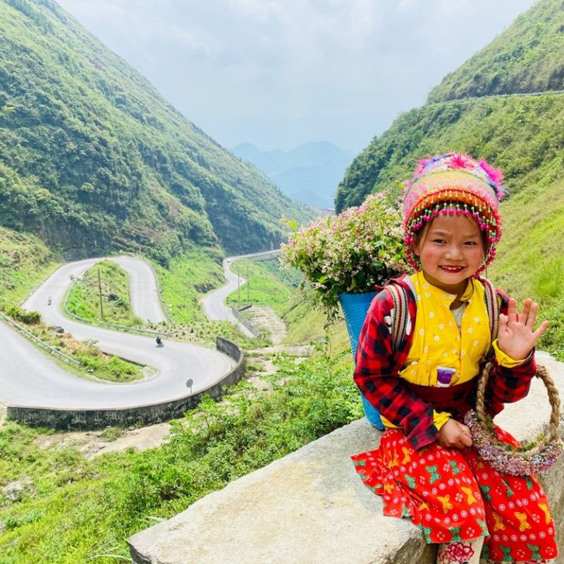
For motorbike enthusiasts who are less confident in their riding skills, the daring ascent along the Tham Ma slope to reach the Dong Van Stone Plateau might seem daunting. Where this slope once tested the endurance of horses carrying goods and food, today it attracts motorbikes and travelers from near and far.
During the journey up this slope, you will experience a refreshing and pristine environment, coupled with the opportunity to admire the majestic natural scenery and the beautifully winding road. Isn’t this a reason why many people wish to extend their stay in Ha Giang even longer?
Lung Cu Flag Tower
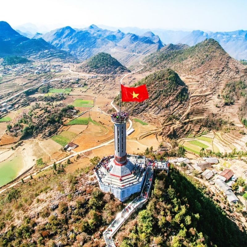
The Lung Cu Flag Tower is situated on the peak of Dragon Mountain at an altitude of 1,470 meters above sea level. As one of the four extreme points of Vietnam, the Lung Cu Flag Tower in Ha Giang marks the northernmost point of the country.
The flagpole was rebuilt in 2010, hoisting a 54-square-meter red flag with a golden star, symbolizing the unity of Vietnam’s 54 ethnic groups, fluttering more than 33 meters high. The Lung Cu Flag Tower features an octagonal shape with eight blue stone bas-relief panels at its base, depicting patterns of the Dong Son bronze drum and glorious historical chapters of the nation.
To reach the flagpole, visitors ascend 839 steps, gradually unveiling the picturesque landscape. Standing atop the mountain, one can feel the cool climate of the Northeastern mountains and a sense of solemn pride. Additionally, visitors can explore the nearby Lolo and Hmong villages and the clear waters of the Dragon’s Eye Lake at the mountain’s base.
Sung La Valley
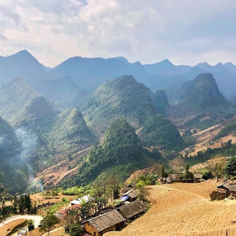
On a beautiful day when you visit Sung La Valley, you’ll truly understand the meaning of unparalleled beauty. Amidst the stone plateau, you’ll find tranquility, simplicity, and romance in gardens bursting with color and modest traditional houses. Each season brings its own charm, with green cornfields and distinctive buckwheat flowers of the highlands, captivating you to the point of forgetting the way back.
In Sung La, you can visit Lung Cam village, home to the H’mong and Lo Lo people. The rustic and simple charm of this place gained fame as the backdrop for the famous movie “The Story of Pao,” featuring a nearly century-old house. Around January and February, this area is engulfed in blossoming peach, plum, and apricot trees, and the stunning rose valleys amidst the vast wilderness.
Quan Ba Heaven Gate
The Quan Ba Twin Mountains, also known as the Fairy Bosom Mountains, are renowned for their unique shape, featuring two parallel peaks. Linked with the legend of the miraculous fairy milk, the surrounding area boasts a pleasantly cool climate and the flowing Mien River, nurturing lush fields.
The Quan Ba Heaven Gate is situated at an altitude of 1,500 meters above sea level. Strategically positioned between two mountain peaks and close to the horizon, it offers visitors a breathtaking view where the beauty of heaven and earth converges before their eyes. This spot is also an ideal location for cloud hunting, with gentle mists enveloping the mountain slopes.


Lung Khuy Cave
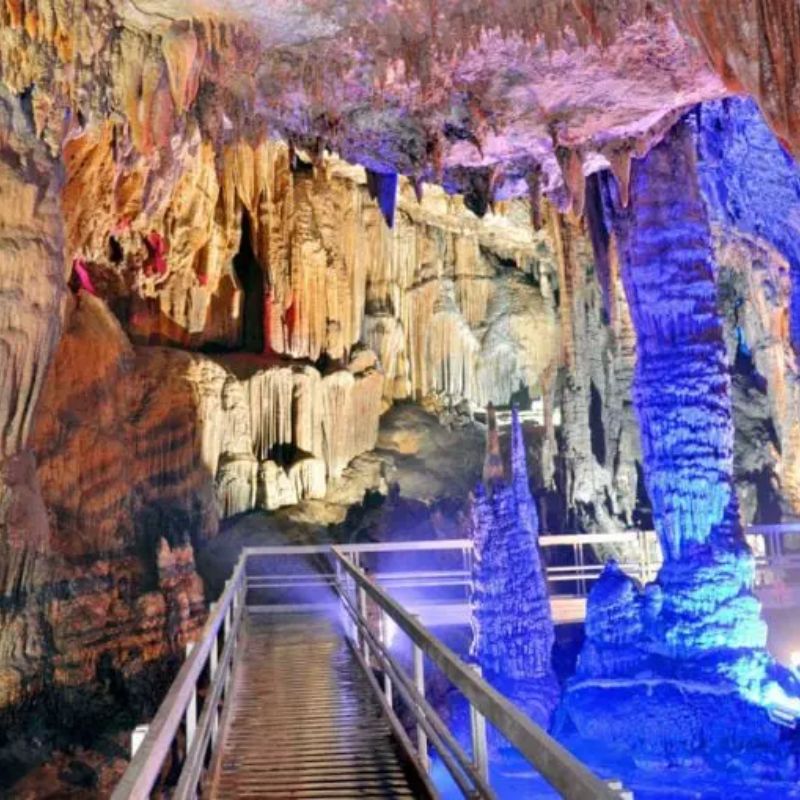
The Lung Khuy Cave, nestled halfway up the mountain in Lung Khuy village, is located about 10 kilometers from the center of Quan Ba district. Discovered in 2015, Lung Khuy quickly became a source of pride and a popular tourist destination in Ha Giang.
The cave extends over 1,000 meters, featuring high rock domes reaching up to 200 meters. Venturing deeper inside, visitors can marvel at the array of glittering primitive limestone stalactites in various shapes closely packed together. Additionally, the cave houses an interesting forest of stone ‘Ngoc Cau’ trees and walls that emit musical sounds when struck, offering an intriguing experience for tourists.
Exploring Lung Khuy Cave also includes hearing about the spiritual legends associated with the cave, as told by the Mong people living at the mountain’s base. For those trekking or motorbiking, it’s important to follow directions carefully, as the cave entrance is somewhat hidden on the mountain path.
Hoang Su Phi
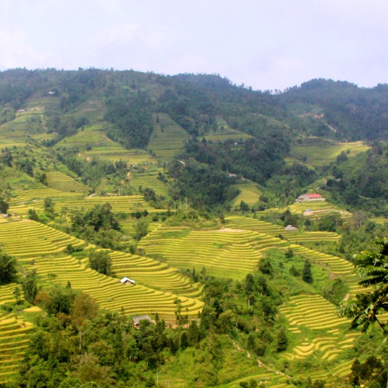
Hoang Su Phi in Ha Giang is a famed tourist destination, especially celebrated for its terraced fields that turn a shimmering gold during the rice harvest season. Here, visitors can not only explore the scenery but also learn about the daily lives, customs, and culture of the local ethnic communities. The terraced fields in this area are often likened to glistening golden steps leading up to heaven.
Immersing oneself in the breathtaking landscapes at dawn and dusk, one feels a sense of peace and tranquility. This place, with its vast forests, endless terraced fields, and traditional stilt houses shrouded in mystical fog, captivates travelers. When visiting Hoang Su Phi in Ha Giang, tourists often explore villages such as Luoc, Nam Ty, San Sa Ho, Ban Phung, Ho Thau, and Thong Nguyen.
Among these, Ban Luoc and Ban Phung are particularly notable for their stunning terraced fields, which from below look like layered silver coins. Recognized as a national heritage site in 2012, the Hoang Su Phi terraced fields are best visited during the harvest season (September – October) to witness the breathtaking landscape akin to a golden carpet laid out across the hills.
As our exploration of the Ha Giang Loop comes to a close, we’re left with a deeper appreciation for the stunning landscapes and rich cultural tapestry of northern Vietnam. This journey has not just been about conquering winding mountain roads; it’s been an adventure into the heart of a region where nature and culture intertwine beautifully. Whether you’re an adventure seeker, a cultural enthusiast, or simply a lover of natural beauty, the Ha Giang Loop offers an experience that resonates long after the journey ends.
FAQs
What are the key highlights of the Ha Giang Loop?
The Ha Giang Loop is renowned for its stunning landscapes, including the Ma Pi Leng Pass, the Dong Van Karst Plateau Geopark, and the Lung Cu Flag Tower. The loop also offers rich cultural experiences in various ethnic minority villages.
How difficult is the Ha Giang Loop for motorbike riders?
The loop is considered challenging due to its winding roads and steep inclines. It’s recommended for intermediate to experienced riders. Beginners should exercise caution or consider guided tours.
What is the significance of the Lung Cu Flag Tower on the Ha Giang Loop?
The Lung Cu Flag Tower is a symbol of national sovereignty, marking the northernmost point of Vietnam. It offers panoramic views of the surrounding landscapes.